
- Home
- 2022 Bonneville to Astoria paddle
2022 Columbia River paddle report
Hello Paddlers who still like to camp without RVs or trailers!
Ever since reading about the Columbia River water trail https://www.estuarypartnership.org/water-trails/columbia-river, I've been interested in doing a paddle and seeing some of the sights of of the "Great River of the West".
So last Oct 2021 I had my little plan put together, camping waypoints loaded into my GPS and was driving to the put in when my wife got a call saying she had tested positive for COVID. As she was going to drive my truck home, we turned around and I cancelled the trip about 1/2 hour from launching at Hamilton Island boat ramp at Bonneville dam. I was likely to come down with Coronavirus and didn't want to worry about her having it alone or me getting it and suffering the effects while in my tent on rainy beaches with strenuous days ahead.
So my plan lingered. My next plan was to reschedule doing it this October with the addition of my paddling partner of various multi week unsupported Canadian and Alaskan expeditions. Cris Lewis got intrigued with a "flat water river paddle" during this summer's expedition rounding Cape Scott at the top of Vancouver Island where occasional high surf forecasts hampered our plans. So we tweaked my outline of a plan, fleshed out the details, potential daily distances and created a spreadsheet of dates, miles per day, target and back up camping locations and comments of fun and historical places to see along the way This trip was not intended as a race to complete in record time, but rather a leisurely low stress paddle to enjoy the sights. With decades of logistical trip planning and GPS experience, Cris is a super asset to paddle with. I've learned most if not all my GPS and logistical skills from Cris.
Our campsites were:
- Oct. 4 Night before launch-Lewis and Clark at Bonneville- convenient but poorly managed. I suggest pre launch camping at Beacon Rock State Park. They have 2 sites near the water. By prior arrangement with the US Army Corps or Engineers, I left my truck at the Hamilton Island boat launch for up to 10 days with an official " special event permit" on my dashboard.
- Oct. 5 Reed Isl. SW side
- Oct. 6 Lemon Isl. NW tip facing PDX with portable toilet nearby.
- Oct. 7 Bachelor Isl. SW tip
- Oct. 8 Bachelor Isl. exploration/ circumnavigation of Bachelor Isl. slough.
- Oct. 9 McMenamins Kalama lodge, with secure docking facility in a boat harbor, a nice mid way treat.
- Oct. 10 Walker Island NW tip
- Oct. 11 Puget Isl. SE tip. On charts this end of the island is called Brown or Whites Island. It's a nicely maintained fishing camp spot.
- Oct. 12 Skamokawa Vista Park- toilets, hot showers, walk to nearby town. This would be a good location for OOPS group campground and an exploration of the Lewis and Clark National Wildlife Refuge.
- Oct. 13 Rice Isl. SW side
- Oct. 14 Astoria- to East Basin Mooring Ramp (via Mott Isl. detour for Geocache search.)
Total miles: 108- excluding Bachelor Island Circumnavigation.
The Columbia River trail website does not include latitude and longitude coordinates for their camping locations but uses a google earth looking map with camping icons where campsites are indicated to be. Using a Garmin Homeport program on a PC I initially located the campsites I was interested in using google earth, added other features such as where to possible load water and find toilets. Even with very accurate waypoints some of our rustic campsites were hard to find. The river in the course of just a few years takes out trees, erodes banks and as many of the sites themselves are unused, become overgrown.
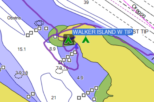
To illustrate this, here are some screenshots of a campsite at Walker Island, west tip. The River Trail indicated site and landing (below) was so choked with downed trees that we didn't see it.
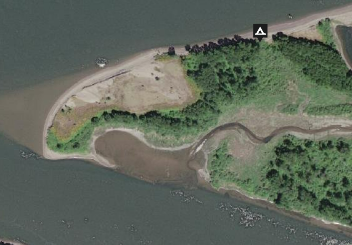
And the site we found after some bushwhacking so we way-pointed it at N46 09.042 W123 03.266
Tent icon below.
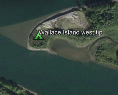
This is how it appears on our Garmins. My track illustrates searching for where a suitable camp might be.
Photos:
- My tent at this campsite Here (link dead)
- Other campsites
- Prijon Kodiak kayaks
The boats we used were German made Prijon Kodiaks made of hard plastic with rudders.
They are super tankers which can hold 3 bear cans and lots of gear. They are rugged, roomy and inexpensive to buy (used).
The tide and current forecasts were available from websites pertinent to the Columbia River that we preprinted and were also available as features of the Garmin GPS 78SC.
Marine weather reports on our VHS radios were not too useful as the reports are mainly coastal so we cheated turning on our our I-phones and used weather apps for that.
The paper chart we carried is the Lower Columbia River "Fish n Map" Bonneville to Pacific Ocean.
We carried Compasses on our decks. In fog, and using a Garmin we could establish headings to follow until the fog lifted. The Garmins could keep us out of the shipping channels but we had to listen for smaller boats.
After reading the notes about paddling the lower Columbia that OOPS members generously shared with me and reading a few books, we were expecting and ready for fierce winds, rains, cold October drizzly days and multiple nights of rainy camps.
There was a saying coined by uber solo expeditioner Mike Higgins of BASK: "Too bad about the weather". This was our almost daily mantra as we experienced sunny days and so much sun we needed to find shade in camp and looked for trees for our tents. With mostly clear skies, we enjoyed very full moons, moonrises and sets and sunsets over the broad river. Each campsite offered different views of moon, sun, stars and planets. With calm and glassy water, barely any wind, and a tailwind on the days closest to Astoria, we were counting our lucky stars. I can only take partial credit for a morning ebb (predictable and calculable) which helped us tremendously on the lower reaches of the river where tide and wind begins to play a large part of river paddling. I swam many times most afternoons and with so much sun was able to do and dry laundry. These conditions, including assistance on the upper reaches from the dam current made a couple of long distance days (20+ miles) much easier; most days we paddled 14-18 miles and were off the water before the opposing flood current or any winds hit. But breaking camp, cooking, loading, paddling, and repeating the process daily adds up to a lot of work.
The Columbia River, "Nichi-wana" (as first nations called it) has long been a commercial artery of the pacific northwest, beginning with native Americans using it as a trade and transportation route. Today it's a world conduit for the agricultural, manufacturing and extractive industries that use it's channels for major shipping carriers. Yet wildlife abounds. Nightly, we enjoyed watching giant flocks of geese and ducks creating the most beautiful long ribbons in skies backlit by setting suns or rising moons. Crickets and frogs were my symphony on the land side of my tent, lapping water was on the river side, joined by coyotes howling in the distance. I've seen lots of Great Blue Herons but never witnessed them flying together in a formation of 8 as we saw near the Heron rookery on Bachelor Island. For paddlers who like wildlife photography, this is a great camping paddle as one gets a chance to experience a variety of the Columbia's moods, features and critters.
If you're a Geocacher, as Cris is, there are many islands with those pesky little things to look for if not find.
General comments:
- Advance researching the river currents, ebbs and floods is very helpful.
- Choosing south facing camping beaches gives you some sun and nice views.
- Planning around full moons may eliminate the use of headlamps at night and adds the the overall awe inspiring beauty of being on a big river with audible wildlife that is within feet of your tent.
Next year I'd like to put together some paddles that explore more of the Columbia perhaps below Bachelor Island and the Cathlamet-Skamokawa-Lewis and Clark National Wilderness Refuge area. If any of you are interested, I'm happy to share and answer questions about the waypoints and details. I would like to help make this kind of trip less daunting and plan distances which are attainable. With time and planning it doesn't have to be a paddle only for the hard core.
I've never put together a trip report trying to integrate screenshots, URLs and attachments all together. I have VERY weak computer skills and needed to consult with Cris on even the basic steps of how to do this. Flaws in the final result is altogether my learning process. I'm open to help to keep developing this. To OOPS club members that are techie based, this will seem very rudimentary but I still wanted to share it as a fun paddle regardless. I'm an ACA level 4 paddler and not an instructor or Trip Organizer.
Together, Cris and I built a GPX file with many waypoints (attached).
Cris Lewis' blog is worth looking into: oceansandforestsadventures.com
Thanks for looking at this.
Ken Sund, October 2022